JULY 24, 2025 – At my wife’s instigation, I went off campus today for the first time in more than a week. Since she was the one to suggest a field trip, she went too—wink, wink. She navigated; I drove. Our excursion took us from the Red Cabin on the weather-bound shores of Grindstone Lake, about 70 miles southeast of Duluth/Superior—as the eagle flies—across the countryside due north to the south shore of Lake Superior west of Port Wing, thence east to Bayfield (and Madeline Island), before dropping back down to Cable, Hayward and finally, the Red Cabin.
Despite sketchy weather at the outset, by mid-morning we were in the sun and remained so until it set just past our return. I should qualify that statement by noting that all day long, the sun was filtered by smoke from Canadian forest fires[1]. Ironically, this smoke-filled air made for some interesting long-view landscapes, especially if I pretended the smoke was fog.[2]
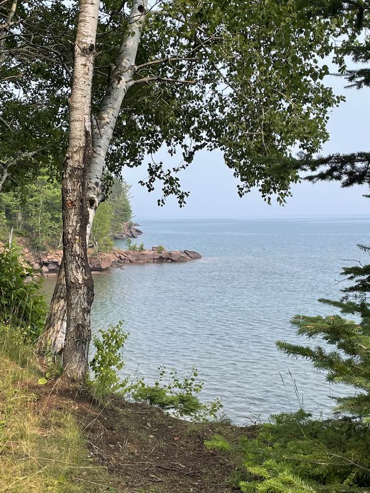
Beth and I were not total strangers to the southern shore of Lake Superior. Over the years we’ve taken several expeditions up there. The infrequency of our visits, however, had led to a gradual fading of impressions. We think of Grindstone Lake, nearly a three-hour drive from the Twin Cities, to be plenty north. But Port Wing is another 65 miles straight north, and Silver Bay, Minnesota directly across Lake Superior from Port Wing is another 30 miles, and the Canadian border—again, if you were heading straight north, would be yet another 60 miles. Even at that location you’d have a long way to go—farther north—before you were beyond “southern Canada.”
What was interesting to us on today’s trip was the change in vegetation and landscape that occurs just north of Hayward. Around Grindstone Lake, mixed pine and hardwood forests dominate, but on the other side of town, you enter a zone that looks more like the taiga—lots of spruce that are typical of northern latitudes. Part of this appearance is the result of harsher winters—though traditionally, the winters in our neck of the woods have been quite extreme. The biggest factor is closer proximity to “Gitche Gumee,” as the native people called the largest of the Great Lakes, both in surface area and water volume.
The other big difference between the region south of us and the countryside north is the paucity of civilization going north. There’s the two-lane road, of course, but between Hayward and Port Wing, we drove past far fewer farms than we see in the other direction, and the chance for gas or anything else for purchase is nearly non-existent until you reach Port Wing, which, by the way, is itself so small, it’s unincorporated.
It does have a store, however, called, “The Store,” in a low-lying, weather-beaten cinderblock structure that’s older than dirt. Next to the entrance, you can buy ice, pick up some firewood and a tank of propane for your camper trailer, and, I noticed, return your library book. Inside “The Store” you could treat yourself to a package of smoked trout harvested straight out of the nearby waters of Gitche Gumee. Back outside you could buy gas for $2.99 a gallon, which you should, even if your gas gauge says you’ve still got half a tank, because given the dearth of gas stations in this part of Wisconsin, you don’t know when you might wish you’d filled the tank when you’d had the chance.
The next settlement, “Cornucopia,” is known for its kayaking outfitters. As we drove around the block to weigh our eating options, we rolled past many exceptionally fit people returning or setting out on a rigorous workout on nearby waters. The leading fish menu establishment, however, was closed, and the second choice eatery, across the street from the fish place and next door to “Wisconsin’s northernmost post office” served burgers and wraps but no fish. It was therefore a no-go, as far as Beth was concerned.
We continued our journey to Bayfield, well known to Twin Citians as the gateway to the Apostle Islands National Seashore, “big water” sailing, the annual fall apple festival and its Big Top Chataqua concerts during the summer. The official population, according to the 2020 census, was only 584, but the summer population swells to around 10,000. Nestled up against steep rising terrain where its famous peach and apple orchards thrive, Bayfield offers a satisfying “shopping experience” for those in search of quality goods, arts and crafts, a choice of decent restaurants and one long-time famous gourmet establishment, the Rittenhouse Inn, and a grand view of Chequamegon Bay to the south, the North Channel to . . . you guessed, it, the north . . . and Madeline Island straight ahead (east) from the mainland.
In the summer, car ferries run every half hour between Bayfield and the island. Once you land on the island, there’s a lot to explore, from cliffs to beaches that run forever, forests and the usual complement of little shops, pubs and restaurants close to the ferry. The island also offers chamber music concerts during the summer and is home to the Madeline Island School of the Arts, which we passed while more than a dozen adult students were hard at work on their pleine air easels. Despite all the attractions, the island looks no more touristy today than it did on our first visit together there nearly 40 years ago.
What is new, however, is a re-vamped museum dedicated to the native history of the island and beyond. We arrived just 30 minutes before closing time, so the director, a member of the nearby Red Cliff Band of Ojibwe, waived our admission fee, and later, when I expressed an appreciation for the fine displays, he engaged us in the earnest telling of the Legend of the Thunderbird (Animikiig or Binesi, in Ojibwe). This soft-spoken gentleman was not that old—though when you’re my age or older, more and more people seem to be less and less “old—but his genuine desire to welcome and educate visitors suggested to me that once he becomes an “elder” chronologically, he will most certainly be universally revered as one.
The museum has done a wonderful job of curating extensive displays from the original museum, founded a century ago. Anyone who makes the effort to reach Madeline Island should include a proper visit to this well run display and repository of the historical record.
After steaming back to Bayfield, we attempted to eat on an attractive elevated patio overlooking the harbor, but tables were in high demand. We decided to head back to the Red Cabin.
Throughout today’s scenic drive were signs of humor: “White Trash Storage,” for example; and outside an old roadside abode without neighbors on either side for miles, a large painted sign that read, “Finnsville. Pop. 2” (a century ago, many Finns and Swedes settled in the region); then there was my favorite—a sign identifying a creek we were about to cross as, “Fish Creek,” juxtaposed to a companion sign that read, “No Fishing From Bridge.”
Beth and I snapped many pictures—how could we not, given all the grand scenery we encountered? But my best pic was the one not taken, and it was quite a bit south of Lake Superior; just south of Cable, actually, near the northern terminus of the American Birkebeiner Ski Race. As we drove toward the next town of Seeley,[3] the narrow (at that point) Namekagon River bends and runs right along the highway for a few hundred meters. When an opening appeared among the trees I caught a glimpse of the river as it runs south. The reclining sun was still high enough to cast its rays over the spires of the fir trees on the opposite side of the waterway. The Namekagon was now a river of orange-gold. In that instant I realized, Now there is a scene waiting to be painted. But I’m no painter, and a photograph, I thought, would be too easy. I kept driving, clutching the memory, then storing it—long-term. There will be many more such scenes; many more.
Subscribe to this blog and receive notifications of new posts by email.
© 2025 by Eric Nilsson


This phenomenon has become a regular occurrence over the past few years. Upon our return to the Red Cabin—where the smoke had caused the opposite shoreline had lost its familiar definition, I investigated a bit online in search of information on the history of Canadian wild fires. Despite having grown up here, I don’t remember “air quality alerts” being issued much before 2020. Granted, the data are slim going back in time, but a Canadian cartographer has attempted to map the frequency and intensity of forest fires across Canada. Not surprisingly, the trend line over the last century turned into a proverbial “hockey stick” about three years ago. I, for one, find this disturbing.
[3] Known primarily for a bar and burger place on one side of the road and directly opposite, the turnoff to “Double O,” the county road that crosses the Birkebeiner Trail at the halfway mark (26 km). The only other notable establishment in “town” is the Vortranz sawmill, which has been there forever, and where you can have your own logs milled—assuming you can get haul your own logs.